The
software product developed by VisionOnSky Co., Ltd.
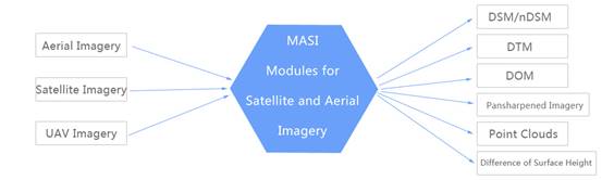
MASI
software independently developed by VisionOnSky
VisionOnSky
Co., Ltd. has developed MASI (Modules for Aerial and Satellite Imagery) software.
The latest version is 6.0. It includes modules of stereo matching, automatic
DSM extraction, DSM2DTM, orthorectification, automatic
3D modeling with true color textures, change finding of surface height, automatic
mosaic, volume calculation, extraction of building attributes, and some interactive
tools for aerial, ADS, satellite and UAV images, respectively. It also has pansharpening of satellite image, the automatic orientation
and bundle adjustment for a stereo, triplet and block of satellite images. The
whole flowcharts for aerial, ADS, satellite and UAV images, respectively, are
fulfilled. After the abovementioned flowcharts, dense point clouds, DSM, DTM, nDSM, orthorectified image, pansharpened image and difference of surface height are
produced. The software supports Windows OS and Linux OS, and can run on
multi-core computer and cluster computer. The parallel techniques with
different processing levels can leverage computational resources of the two
types of computing platforms to the maximum extent.
MASI software
can be applied to these aspects: (1) generation of mapping products (point
clouds, DSM, DTM, orthorectified image, and pansharpened image); (2) automatically finding change of
surface height (used in the automatic finding of new buildings, the unplanned
buildings and the removed buildings, and estimating their corresponding
accurate height); (3) monitoring the construction progress of new city, big
residential district and huge engineering project; (4) testimony of land
expropriation and housing demolition; (5) estimating the exploited volume of
ores located on surface; (6) digital city and reconstruction of 3D scene; (7)
collection of commercial and military intelligence; (8) accurate estimation of
height of buildings and trees.
Released
versions (the following items can be accessed by clicking):
VisionOnSky
Co., Ltd. released MASI Version 6.0 software, 04/2023
VisionOnSky
Co., Ltd. released MASI Version 3.0 software, 09/2018
VisionOnSky
Co., Ltd. released MASI Version 2.0 software, 03/2018